This section focuses exclusively on siting, designing and implementing bikeshare stations,
which are directly linked to the reliability and usefulness of the system. Operational aspects
required for system implementation such as staffing, customer service, marketing, etc. are
discussed in section 7.2
4.1.1 STATION LOCATION
ESTIMATING COSTS
Choosing appropriate station locations is critical to ensuring that the station-based system
will have high usage and turnover. Stations should be situated such that they can be found at
regular and convenient intervals throughout the service area and are in desirable locations
that generate usage throughout the day. Station design and location should consider the
surrounding cityscape.
For even more information on bikeshare station siting, consult NACTO’s Bike Share Siting
guide.
IDEAL STATION LOCATION CHARACTERISTICS
Stations are better located in sunny spaces when possible, rather than under trees, so that the
bikes dry off more quickly after it rains. Clear access to the sun is also important if the station
is solar-powered. Locations will need to balance visibility of the system with integration into
the street environment. Often, larger stations in prominent areas are designed to stand out
against their landscape, while stations in residential areas are meant to blend in to the
streetscape. Stations should not be placed on footpaths unless there is at least two meters of
clear space for pedestrians walking beside the station, and more space should be provided
where there is higher pedestrian traffic. At intersections, space is often more readily available
on the minor street than on the main thoroughfare.
In general, bikeshare stations should:
Achieve target station density
Defined in the feasibility study (see section 3.2), station density should be used to achieve
mostly uniform coverage throughout the service area. This provides a level of redundancy in
the system, so that when stations are full or empty, another station is always nearby as a
backup. Exceptions to uniform coverage may arise when siting stations in large parks or other
recreational settings.

Connect to transit
Bikeshare is inherently complementary to transit, so stations should be sited adjacent to mass transit stops and stations, helping passengers connect more easily and quickly to their destinations while helping to address transit’s first-last-kilometer problem.
Support bike infrastructure
Whenever possible, stations should be located along existing bike lanes or on streets that are safe and

accessible for cyclists. In some cases, stations can actually be used as a barrier between a bike lane and traffic, offering increased protection for all riders.
Serve mixed-use areas
Ideal station locations are mixed-use areas that generate activity throughout the day and night, ensuring that bikes will be used during peak and off-peak hours. For example, a station that is situated between an office complex and bars and restaurants is likely to be utilized by commuters in the
morning and evening, and by the restaurant and bar customers during midday and evening hours.

Avoid physical barriers
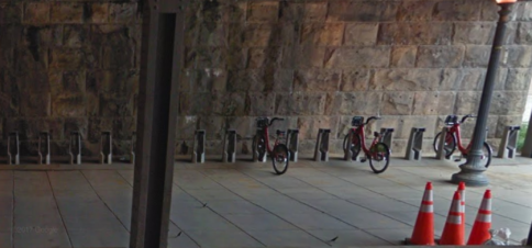
Stations should not be placed next to barriers like train tracks or in single-use areas such as a large gated park or factory. Barriers reduce the effectiveness of the bikes by limiting the area that can be reached on a single trip. Stations in single-use areas have lower usage because there are fewer activities to attract a variety of users. Furthermore, underused areas, like underpasses, while interesting in terms of activating underutilized space, should be carefully considered for potential safety concerns.
Offer multiple access points
Stations are best situated on or near corners, so that users can access and egress from multiple directions.
Provide access to the electrical grid (e-bike charging only)
Stations designed to operate as charging locations for pedal assist e-bikes often require a
connection to the electrical grid to charge. This may require consultation with the electrical utility.
The city should specify which guidelines it wants to follow as a framework for determining the
exact location of each station. Determining ideal station location is a multi-step process:
4.1.1a Create a first draft of station locations
The idea is to have a roughly even distribution of stations while working within the constraints
of the environment. Creating a first draft of station locations can be done in one of two ways:
Grid approach
Stations are mapped out remotely using a grid to ensure even coverage, and then verified with
site visits. To map locations remotely, draw a grid of 1-by-1-kilometer squares over a base map
of the service area, using either a computer program (Google Maps, GIS, etc.) or a paper map,
marker, and ruler. The grid provides a simple foundation for evenly distributed stations. The
base map should show transit stations and bicycle lanes, as well as any other important
demand generators or facilities. Then, applying the station density parameter and station
location guidelines, calculate the number of locations per grid square. This ensures that
stations are spaced evenly throughout the service area. For example, if the desired station
density is 14 stations per square kilometer, 14 stations should be placed more or less evenly in
each grid square. The grid can be subdivided into high station-density and low station-density
zones if desired, though a uniformly high-density approach is recommended for most areas.
Field approach
Station locations are identified in the field and then analyzed remotely and adjusted where there
is too much or too little coverage. If the planning team starts in the field, it will need to ensure
continuous coverage by drawing buffers around each proposed station (using a diameter of 300-
500 meters). The areas left without coverage will, then, need to be analyzed to see if a station
should be added, and, if so, where. While the goal is to use the station density parameter to
ensure uniform coverage, this is rarely achieved across the board because existing infrastructure
and land uses often dictate how many and what size stations are needed.
4.1.1.b Engage community groups to build support and ensure equity
Station locations identified through either the grid or field approach detailed above should be
vetted by a team of stakeholders that includes residents, local business owners, operator(s),
city officials, etc. to ensure that all considerations are being addressed. Engaging stakeholders
in the station location process—especially early enough to actually integrate feedback into the
final decision making—is a good way to build support and community buy-in for the project. As
part of their initial planning, both New York City and Washington, DC assigned a specific
number of stations for given areas to the most local political representatives of those areas,
and had citizens from those constituencies select the actual station locations. This
transparency and willingness to hear feedback from residents and business owners at the
start of (and throughout) the planning process could help to quell fears of bikeshare as a
symbol of gentrification, and ensure equitable access to stations across demographic groups.

Community workshops to present draft plans and solicit input on station planning provide an
opportunity to disseminate information about bikeshare to people living in neighborhoods
where the system will be introduced (or expanded into), and will be valuable for finalizing
where to place bikeshare stations and understanding demand. Starting in 2015, New York City’s
Department of Transportation conducted more than 20 community outreach meetings to
garner resident input on locations for new Citi Bike stations in Brooklyn, Queens, and
Manhattan. Local residents were given the opportunity to discuss potential station locations
with their community board, elected officials, and other community organizations.[28] Similarly,
Ford GoBike (previously Bay Area Bikeshare) partnered with other shared mobility operators to
host community outreach events in Oakland, California at which residents were asked to draw
maps of their transportation routines to help inform bikeshare station planning.[29]
Another increasingly popular method—used currently by Chicago, Boston, Austin, and others—
is to crowdsource station locations through the system’s website and/or mobile app. This can
help to identify high-demand areas and, while crowdsourcing will not determine the exact
locations of individual stations, it does enable residents to identify proximate areas that they
feel should be served by the system. Washington, DC’s Capital Bikeshare uses a slightly
different approach to solicit input on station locations: including space in the system’s
biannual survey for members to suggest locations. Despite the outreach approach, exact
locations for stations will need to be finalized through analysis is done by the planning team.

4.1.1.c Finalize station locations through site visits
Despite the approach used to generate the first draft of station locations, the exact
positioning of each station will require a site visit.
The planning team conducting site visits should be equipped with:
- A bicycle to conduct the site visit is recommended because it gives planners a sense of
the service area from the perspective of a cyclist. - GPS-enabled mapping device to verify latitude-longitude locations already identified
- Tape measure or measuring wheel.
- Camera to document potential station locations.
Visit each potential station location and examine the area to determine the specific location
that will best accommodate the bikeshare station. Using a tape measure, determine if there is
sufficient space for the station; this will depend on how many bikes are projected to be at that
station. Depending on the bike docking design, each bike will need a space that is
approximately 2 meters long and 0.7–1.5 meters wide. Locations that enable station growth, if
warranted, are preferred. In general, stations will have to align with local permitting processes
for street furniture, and engineering plans may need to be submitted to city agencies.
A variety of options for station locations should be considered:

On-street parking spaces
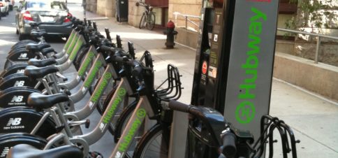
Converted car parking spaces are an ideal location for bikeshare parking stations. Boston recognized the benefits of designating curb space for its Hubway bikeshare stations in its 2016 Future of Parking in Boston report.

Sidewalk landscape zone
Space that is not used often by pedestrians, such as in between trees or planter boxes or next to other infrastructure such as pedestrian bridges or utility installations, can be used for bikeshare parking stations.

Dead spaces
While not priority locations, areas beneath flyovers and bridges—which are often underutilized—that are close to destinations and have adequate pedestrian conditions and solar access can serve as locations for stations.
Once the specific location for each bikeshare station is established, it should be place-marked using a GPS system (or pinpointed on a smartphone) or marked on a physical map. Photos should be taken and precise details noted about the ideal station size, positioning, configuration, given certain surroundings, etc. These coordinates, notes, and photos should then be given to the station installation contractor to safeguard against location or positioning errors, which can be common.
4.1.1.d Revisit and Analyze Station Performance

After the system launches, the implementing agency should plan to perform regular assessments of station locations, informed by data generated from system users. Underused stations may benefit from resizing (station sizing is discussed in subsection 4.1.2) relocation and/or from additional signage or wayfinding interventions. User surveys (both in-person at stations and online) may also help to optimize station locations.
4.1.2 STATION SIZING
Once the station locations have been chosen, the next decision will be how big those stations should be, including the number of bikes and the number of docking stations. This will depend on the demand of the area, which can be estimated using several different methods:
- Identify demand drivers
Understand the variation in population, employment, and building density throughout the
service area; high density often indicates high demand. Also consider the station’s placement
within the context of the overall network. Outlying or edge stations are more difficult to
service and may be larger in size to avoid leaving a rider with no alternatives if the station is
full or empty. Lastly, evaluate existing mode splits and major attractions or points of interest
that may create a high number of trips. - Conduct surveys
Interview transit riders and/or pedestrians to better understand where people are going and if
they would consider using a bike for all or part of their trip if the option were available. - Hold community workshops
Consult the public to understand area demand and discuss what size stations fit best in what
locations.
To simplify the planning process, stations can be divided into small (5-7 bikes), medium (10-15
bikes) and large (20+ bikes) so that each station size is not overly deterministic. Using modular
stations mitigates some of the risk of wrongly sizing stations, as it is easier to add or remove
docking spaces once the system opens. This is discussed in greater detail in the next
subsection (4.1.3). For systems utilizing virtual stations—geofenced hubs with or without
bicycle racks—modifying the station requires adding or removing bicycle racks and/or
modifying the geofence boundaries.
4.1.3 STATION TYPE AND DESIGN
Station design is a function of the level of demand, the amount of space available, the
cityscape, and the desired visual impact on the urban environment. The choice of station type
will need to take into account the IT requirements for each option. Stations are composed of
bicycles, docking spaces, and terminals, also known as kiosks. Docking spaces are where the
bikes are parked and locked when not in use. In some systems, users can check out bikes at
the docking space. Docking spaces represent the single largest capital cost in many systems,
but a greater number of docking spaces helps cut operating costs by reducing the need for
rebalancing of the bikes. This Guide uses terminals to define the places where users can get
information about the system, but these can also be called kiosks or totems. Stations can also
include advertising boards that can be rented as a source of revenue for the system (see
subsection 7.3.6 Advertising Revenue).
There are two main types of bikeshare stations:

Modular
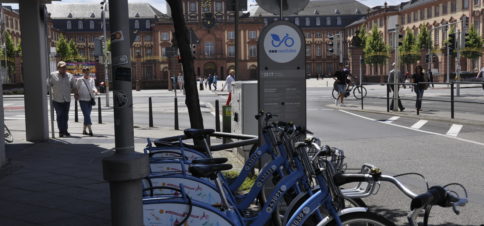
Modular stations are easily moved, usually constructed on a base that is then bolted into the concrete or asphalt. In some cases, these stations are powered by solar power because they do not connect directly to the city’s electrical grid. Montreal’s BIXI system pioneered this type of powered modular station design, which is now used in many other cities such as New York City and Melbourne. It consists of a heavy base with docking locations and a terminal for information, registration, and payment, all of which can be relocated. In other cases, modular stations are not powered, and simply provide a branded, designated location to which bikeshare bikes can be locked. Social Bicycle-operated systems across several countries, nextbike-operated systems in Europe, and Zagster-operated systems in the US use these nonpowered modular stations.
If a station location is found to be inadequate after it is built—as is sometimes discovered after some weeks of operation—modular stations can be fairly easily relocated to a place with better demand.
Stations like this are also more easily scaled up or down, adding or removing docking
spaces or racks as real usage is determined after opening.
Permanent
These stations require excavation and trenching to reach the power source. This requires a
longer time frame to implement and may entail a more onerous approval process. Permanent
stations may be preferred for systems with pedal assist e-bikes, so that bikes can be charged
while they are checked into a station.
If a station location is found to be inadequate after it is built—as is sometimes discovered
after some weeks of operation—modular stations can be fairly easily relocated to a place with
better demand. Stations like this are also more easily scaled up or down, adding or removing
docking spaces or racks as real usage is determined after opening.

Docking spaces
Each space docks one bicycle
The number of spaces determines the size of the station’s footprint, which means there is a great deal of flexibility to adjust the station size to fit the existing urban landscape. This style takes up more space per bike than cycle parking areas, but blends in better with the urban environment and is popular for roadside stations. Bicycles are checked out by customers either at the terminal or at the actual docking space. Docking spaces can be more user-friendly because a rider simply rolls the bike into and out of the docking space to lock or unlock it.
Bike parking areas
Bicycles are stored together, typically on racks, in a secured area. While less common than docking spaces, bike parking areas can be a good option for larger stations—that is, more than 50 bicycles—because parking racks can hold more bikes per square meter than docking spaces. Bicycle parking areas are best utilized in underused spaces, such as those beneath overpasses or in suburban areas, where land space is less scarce than in the downtown core. At stations with cycle parking areas, bicycles are checked in and out through a turnstile or similar mechanism. Because these stations require a secure area that is fenced or walled off, they can be more intrusive in the urban landscape. Additionally, bike parking areas that require a bike be lifted onto the rack could pose barriers to less-able riders.